Colleen Bready's Forecast: Cool air mass, cooler temperatures
You couldn’t be blamed if you’re wondering what happened to summer on Wednesday. Daytime highs across Manitoba today will only reach the mid-teens to low 20s.
A cool air mass that is slowly moving southward over the province is the main culprit.
Additionally, a pair of lows at the surface and upper levels are dragging showers with them today as they slump southward over the province.
The showers stay well north of Winnipeg this afternoon, mainly affecting central regions and are just further to the north.
But with the direction they’re headed, showers will likely pass through Winnipeg and the southeast starting Thursday morning and be on their way out in the afternoon.
Until then, today will be mostly cloudy in southern areas including Winnipeg, but some sunshine should poke through later this afternoon.
Areas closer to Ontario including Pinawa and Sprague may see some showers.
Over the border, northwestern Ontario could see anywhere from 10 to 20 mm of showers this afternoon. Thunderstorms can’t be ruled out either.
Once tomorrow’s showers clear out of Winnipeg and southeast, the coolest air will move through the area in the evening.
As for the smoke from wildfires, it’s expected to continue today in west-central and some northwestern areas of Manitoba.


CTVNews.ca Top Stories

'The mom is shattered': Body of employee who died at Halifax Walmart was found by her mother
The Maritime Sikh Society says the body of a young employee who died at a Walmart in Halifax last weekend was found by her mother.
Trudeau announces massive drop in immigration targets as Liberals make major pivot
The federal government is slashing immigration targets to levels that will flatten population growth as Prime Minister Justin Trudeau admits the government did not get the balance right after the COVID-19 pandemic.
BREAKING
BREAKING 4 teens stabbed outside Montreal high school: police
Montreal police say four teenagers suffered stab wounds after an altercation near John F. Kennedy High School in the city's Villeray—Saint-Michel—Parc-Extension borough on Thursday.
'Horrific': Four people dead after Tesla slams into pillar and catches fire on Lake Shore Boulevard in Toronto
Four people are dead and another is in hospital after a Tesla driving through downtown Toronto at a high rate of speed crashed into a guardrail and struck a concrete pillar on Lake Shore Boulevard.
Vince McMahon, embattled former CEO of WWE, sued for allegedly enabling sexual abuse
A new lawsuit alleges Vince McMahon knowingly enabled the sexual exploitation of children by a WWE employee in the 1980s.
B.C. election recounts won't start until Sunday afternoon
Voting officials say recounts in two ridings that could determine the outcome of British Columbia's election won't start until Sunday afternoon.
DEVELOPING
DEVELOPING Woman stabbed to death in park in Ottawa's south end
Emergency crews responded to a call for a stabbing at Paul Landry Park on Uplands Drive, between Paul Anka Drive and Bennett Street, at 11:25 a.m. Thursday.
Stunning fossil trapped in amber reveals previously unknown species that lived during the time of dinosaurs
Diverse firefly species lit up the night during the late Mesozoic period, scientists have confirmed.
More straight couples are calling each other partner. Here's why
Within a year of dating, 31-year-old Siara Rouzer crossed a major relationship milestone. The guy she was seeing was no longer a boyfriend but her partner.
Shopping Trends
The Shopping Trends team is independent of the journalists at CTV News. We may earn a commission when you use our links to shop. Read about us.


Regina
-

Regina police was unaware one of its officers responded to Sask. Party campaign office incident
The Regina Police Service (RPS) says it learned on Thursday that an officer responded to an incident at a Saskatchewan Party campaign office Monday evening and did not inform the service of their response.
-
Sask. RCMP hunt for armed suspects who shot construction worker, stole a truck
The RCMP is warning residents in northeast Saskatchewan to seek shelter and avoid picking up hitchhikers as police search for a group of armed and dangerous suspects.
-
Regina Pats trade local product Sam Oremba to Spokane
The Regina Pats have traded forward and Regina born Sam Oremba to the Spokane Chiefs in exchange for multiple draft picks, the team announced on Thursday.
Saskatoon
-

Sask. RCMP hunt for armed suspects who shot construction worker, stole a truck
The RCMP is warning residents in northeast Saskatchewan to seek shelter and avoid picking up hitchhikers as police search for a group of armed and dangerous suspects.
-
Police investigating multiple suspicious fire in Saskatoon Mayfair neighbourhood
Saskatoon police are investigating a series of suspicious fires that were lit in the Mayfair neighbourhood on Thursday morning.
-
Federal housing minister will work directly with Saskatoon, Regina on homelessness
Federal housing minister Sean Fraser says he’s going to work directly with the cities of Saskatoon and Regina to tackle homeless encampments, after the province ignored his funding offer last month.
Edmonton
-

Edmonton's Remedy Cafe up for sale for $7.6M
You could be the new owner of an iconic Edmonton chain.
-
Father of murdered Beaumont woman's boyfriend to serve prison time after appeal
The man who cut up the body of his grandson's mother is going to prison after the Alberta Court of Appeal overturned his previous sentence.
-
Man hospitalized with life-threatening injuries after Edmonton shooting
One person was taken to hospital with life-threatening injuries after a reported shooting on Wednesday night.
Calgary
-

'It’s brutal': Calgary company steaming mad after Google removes business profile
A Calgary business owner is frustrated and looking for answers after Google removed his business' profile without warning, resulting in a loss of bookings and damage to his company’s reputation.
-
University of Calgary grad students facing 'uncertainty' after recent immigration changes
International graduate students at the University of Calgary say recent changes to the cap on international students, along with more cuts to Canada's immigration targets, is causing uncertainty -- and could drive talent away from the country.
-
Golf carts allowed on roads in some Alberta communities as part of pilot
A town in southern Alberta will be one of the first to let golf carts be driven on select roads as part of a provincial pilot program.
Toronto
-

'Horrific': Four people dead after Tesla slams into pillar and catches fire on Lake Shore Boulevard in Toronto
Four people are dead and another is in hospital after a Tesla driving through downtown Toronto at a high rate of speed crashed into a guardrail and struck a concrete pillar on Lake Shore Boulevard.
-
Ontario family loses dream home after $38K deposit falls through
It's a dream for many Canadians, trying to save up enough money for a down payment on their very first home. That was also the dream for the Esmeralda family, a family of five with two dogs who currently live in a Scarborough apartment building.
-
30-year-old man in life-threatening condition after daylight shooting in North York
A 30-year-old man is fighting for his life in hospital after a daylight shooting in North York Thursday.
Ottawa
-
 DEVELOPING
DEVELOPING Woman stabbed to death in park in Ottawa's south end
Emergency crews responded to a call for a stabbing at Paul Landry Park on Uplands Drive, between Paul Anka Drive and Bennett Street, at 11:25 a.m. Thursday.
-
Man dead, police officer seriously injured in Gatineau, Que.
Quebec’s Bureau of Independent Investigations (BEI) is investigating after police in Gatineau, Que. shot and killed a man who allegedly stabbed an officer during an investigation.
-
Actor Matthew Perry's legacy to live on through Canadian foundation to aid people with addictions
A new organization that aims to help people struggling with addictions officially launches in Ottawa Thursday, named after the late Matthew Perry.
Montreal
-
 BREAKING
BREAKING 4 teens stabbed outside Montreal high school: police
Montreal police say four teenagers suffered stab wounds after an altercation near John F. Kennedy High School in the city's Villeray—Saint-Michel—Parc-Extension borough on Thursday.
-
Montreal's mayor is leaving politics, and she's not alone. Is it the toxic climate for women?
Montreal Mayor Valerie Plante announced Wednesday she would not seek a third mandate. Her decision has many talking about the demands of municipal leadership, particularly for women.
-
How a Montreal school reignited a debate over secularism and Bill 21 in Quebec
An investigation into a climate of fear at a Montreal primary school has reignited a debate about secularism in Quebec's education system, with the provincial government pledging to consider new measures to keep religion out of classrooms.
Atlantic
-
'The mom is shattered': Body of employee who died at Halifax Walmart was found by her mother
The Maritime Sikh Society says the body of a young employee who died at a Walmart in Halifax last weekend was found by her mother.
-
'This sudden loss is felt deeply': Man killed in workplace accident at Moncton tire shop
WorkSafeNB is investigating after a man was killed in a workplace incident at a tire shop in Moncton, N.B., last week.
-
N.S. Liberals accuse former member Fred Tilley of data breach
The Nova Scotia Liberals are accusing former member Fred Tilley of accessing party files one day before he crossed the aisle to join the Progressive Conservatives.
Vancouver
-

B.C. election recounts won't start until Sunday afternoon
Voting officials say recounts in two ridings that could determine the outcome of British Columbia's election won't start until Sunday afternoon.
-
Man charged with arson, assault following house fire in Surrey, B.C.
A 29-year-old man has been charged with arson and assault with a weapon after police were called last week to a fire in the Newton neighbourhood of Surrey, B.C.
-
'It felt like we were in a weird TV show': B.C. rock band's gear stolen on the road in Washington
A B.C. rock band is trying to recover and replace the expensive equipment it needs to make music after their van, and everything inside it, was stolen while on their first American tour.
Vancouver Island
-

B.C. records more than 1,700 drug deaths in first 9 months of 2024
At least 1,749 people have died from toxic and unregulated drugs in British Columbia since the start of the year – a rate of more than six people per day, according to the latest data from the provincial coroner's office.
-
Man charged with arson, assault following house fire in Surrey, B.C.
A 29-year-old man has been charged with arson and assault with a weapon after police were called last week to a fire in the Newton neighbourhood of Surrey, B.C.
-
'His friends buried him': Mounties discover truth about dead officer
Legend has it that on a dark evening in 1988, friends of Supt. Joe Atherton quietly buried his body on the site of the old provincial RCMP headquarters in Vancouver.
Kelowna
-

B.C. homeowner astounded someone managed to steal one of his prized giant pumpkins
Dave Lindsey began growing giant pumpkins to bring a bit of magic to his grandkids' Halloween.
-
B.C. man gets prison sentence, fine for using fake names to buy guns in the U.S.
A U.S. District Court judge in Montana has sentenced a 27-year-old man from Kelowna, B.C., to 18 months in prison for using fake names to buy guns with the aim of selling them in Canada.
-
2nd-degree murder charge laid nearly 2 years after Kelowna stabbing
Nearly two years after a man was stabbed to death in downtown Kelowna, RCMP have made an arrest in the case.
N.L.
-

Remains of missing Kansas man found at scene of western Newfoundland hotel fire
Investigators found the remains of a 77-year-old American man on Wednesday at the scene of a fire that destroyed a hotel in western Newfoundland earlier on the weekend.
-
77-year-old Kansas man missing after hotel fire in western Newfoundland
Police in western Newfoundland say a 77-year-old man visiting the province from Kansas is missing after a fire at a hotel in Deer Lake, N.L.
-
83-year-old Newfoundland musician still playing sold-out shows, even with memory loss
At 2 p.m. on Thursday, the scene at the Lions Club in Clarenville, N.L., rivalled any rowdy St. John's bar that thumps with music late on a weekend night.
Northern Ontario
-
'The mom is shattered': Body of employee who died at Halifax Walmart was found by her mother
The Maritime Sikh Society says the body of a young employee who died at a Walmart in Halifax last weekend was found by her mother.
-
Sudbury police searching for suspect in dangerous driving incident
Greater Sudbury Police have released a photo of a person they say escaped by driving their motor vehicle on a sidewalk past pedestrians and then the wrong way down a one-way street.
-
Several drivers taken to hospital after five-vehicle crash in Parry Sound, man charged
A 72-year-old driver was charged Wednesday with following two closely after a five-vehicle crash sent several people to hospital in Parry Sound.
Barrie
-

Emergency crews extinguish fire at possible encampment in Barrie
Emergency crews were called to attend a fire that broke out in a grassy area in Barrie on Thursday morning.
-
Town bylaw requests Innisfil, Ont. family move Halloween display but homeowner refuses
A haunted house in the Ontario Town of Innisfil is causing a real scare for some people a week before Halloween.
-
Power outage leaves thousands of Barrie residents in the dark
A power outage left thousands of Barrie residents in the dark on Wednesday night.
Kitchener
-

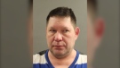
Erick Buhr testifying in his own defense at second-degree murder trial
Erick Buhr, the man charged with second-degree murder in the death of his grandmother, took the stand Thursday to testify in his own defense.
-
University of Waterloo stabber was motivated by hate, Crown argues at sentencing hearing
A triple stabbing at a University of Waterloo gender studies class last year was clearly motivated by hate, prosecutors argued Thursday, pointing to a manifesto written by the man who pleaded guilty in the case and his comments to police.
-
Trudeau announces massive drop in immigration targets as Liberals make major pivot
The federal government is slashing immigration targets to levels that will flatten population growth as Prime Minister Justin Trudeau admits the government did not get the balance right after the COVID-19 pandemic.
London
-
Employee assaulted with stolen alcohol bottle in convenience store robbery
An employee followed the man outside and tried to stop him, however the man hit the employee with one of the bottles of alcohol, physically assaulting them.
-
'We notice a lot of sticky fingers': Shoplifting on the rise in St. Thomas
The St. Thomas Police Service is issuing a warning to local retailers as police deal with a rapid rise in shoplifting cases over the last couple of years.
-
LHSC gives first community update after major restructuring
David Musyj said the process of establishing a new board continues, stressing that it took a longtime for the hospital group to get into the situation it's in and it will take time to make things right.


