
WINNIPEG -- Winnipeggers may have noticed video cameras set up along active transportation routes in different areas of the city.
A spokesperson for the City of Winnipeg told CTV News that nine streets in the city have been designated as temporary active transportation routes to allow for recreational activities amid the COVID-19 pandemic.
They said this allows pedestrians and cyclists to follow social distancing requirements.
According to the City of Winnipeg website, these routes limit motor vehicle traffic to one block throughout the area between 8 a.m. and 8 p.m.
The video cameras are counting to see how often these routes are getting used.
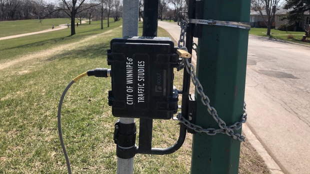
(Source: Karen Mitchell/ CTV News Winnipeg)
The spokesperson said the city is collecting data at all nine sites. The video will be turned into numerical data to record the level of usage.
These routes are in place until Friday, May 29.
"The City will re-evaluate at the end of May to determine if the designations will be extended," the spokesperson said in a written statement.
(Source: Karen Mitchell/ CTV News Winnipeg)
According to the city, video is often used instead of pneumatic traffic tubes when counting cyclists and pedestrians.
Here is a list of the temporary bicycle and active transportation routes in Winnipeg:
- Lyndale Drive - Cromwell Street to Gauvin Street
- Scotia Street - Anderson Avenue (at St. Cross Street) to Armstrong Avenue
- Wellington Crescent - Academy Road (at Wellington Crescent) to Guelph Street
- Wolseley Avenue - Raglan Road to Maryland Street
- Assiniboine Avenue - Bedson Street to Westwood Drive
- Churchill Drive - Hay Street to Jubilee Avenue
- Egerton Road - Bank Avenue to Morier Avenue
- Kildonan Drive - Helmsdale Avenue to Rossmere Crescent & Larchdale Crescent to Irving Place
- Kilkenny Drive - Burgess Avenue to Patricia Avenue and Kings Drive


