Rain, snow hit parts of southern Manitoba as system moves north from the U.S.
Parts of southern Manitoba have been hit by a lot of rain, and even snow, as a low-pressure system moves in from the United States.
Natalie Hasell, a warning preparedness meteorologist with Environment and Climate Change Canada, said the areas closest to the Canada-U.S. border received the most precipitation over the last 24 hours.
Both Deerwood and Morden each reported 69 to 70 millimetres of rain just before 3 p.m. Friday.
Pilot Mound had 56 mm, Carman received 58 mm, and Portage la Prairie reported between 40 and 50 mm.
As for Winnipeg, the city recorded between 20 and 25 mm. Hasell noted Winnipeg may miss out on more precipitation Friday, going into Saturday.
"We might be in a bit of a gap. So we might not get quite as much precipitation in Winnipeg proper, but a lot of the areas around us, and not too far away, are looking very likely to reach our warning numbers," said Hasell.
Despite that, the precipitation is still impacting activities in Winnipeg. The Goldeyes announced the team's game scheduled for Friday has been postponed and will be made up on Saturday.
As well, the St. Andrews Lock and Dam may have to remove part of the moveable dam to deal with the significant rainfall.
"Owners of vessels, barges, and all property on the Red River and its tributaries are advised to protect their property," Public Services and Procurement Canada said in a news release.
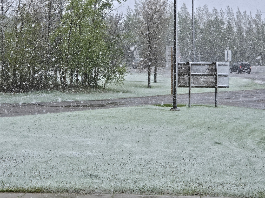 Snow seen at Highway 16 and Highway 10 on May 24, 2024. (Jason Enns)
It wasn't just rain that Manitobans dealt with, as parts of western Manitoba experienced snow Thursday night and Friday morning.
Riding Mountain National Park reported 10 centimetres of snow, while Shiloh reported 8 cm and Brandon saw 2 cm.
Hasell said there was a spot of cold air that caused the precipitation to come down as snow.
"It's mainly rain mixed with snow. It's not entirely snow because we do have some areas where temperatures are just above zero at the surface. It's a bit messy."
She added the snow wasn't a surprise as a number of models were suggesting snow was possible.
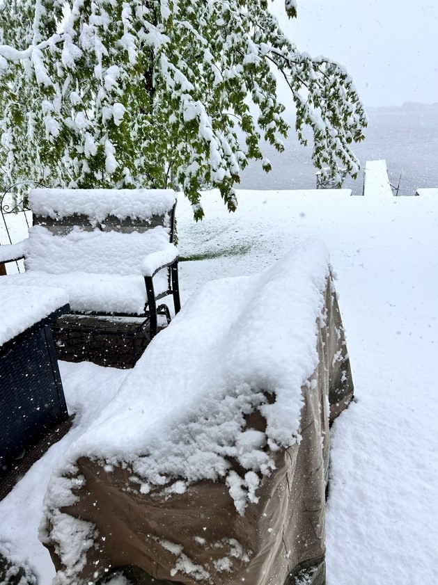 Fresh snow that fell in Killarney on May 24, 2024. (Scott Cockbill)
"It wasn't quite clear how wide or extensive the snow would be. But I think it was mentioned in a number of the forecasts," said Hasell.
As for what this storm could bring over the next 24 hours, Hasell said it will eventually hit the southeastern part of the province and then move north, bringing more precipitation.
"It's not leaving here until sometime tomorrow, or very late tonight at the earliest. But probably in the overnight period. After midnight tonight is probably when these areas south of us are going to be out of it."
With the rain, Hasell warns of the potential of overland flooding, and notes it will be extremely windy as well. She advises people to not try and drive through any standing or moving water, as vehicles could get stuck or even swept away.
Rainfall warnings continue to be in places for areas as far west as Napinka, as far north as Jackhead, and as far east as Vita.
Multiple power outages reported in Manitoba
The snow and rain are also resulting in multiple power outages in Manitoba.
Brandon has 1,568 customers without power, according to Manitoba Hydro, while the Killarney-Turtle Mountain area is dealing with 843 customers without power. The North Norfolk area is dealing with 772 outages right now.
A full map can be viewed on Manitoba Hydro’s website.
It is not known when power will be fully restored.


CTVNews.ca Top Stories

Smith tells Trudeau Alberta will opt out of federal dental plan
Alberta is opting out of the federal dental plan, the premier told the Canadian government late Tuesday afternoon.
One of Canada's most popular vehicles recalled over transmission issue; 95,000 impacted
One of the country's most popular vehicles is being recalled in Canada due to a transmission issue that may impact tens of thousands of drivers.
WikiLeaks' Assange pleads guilty in deal with U.S. that secures his freedom, ends legal fight
WikiLeaks founder Julian Assange has pleaded guilty to obtaining and publishing U.S. military secrets in a deal with Justice Department prosecutors that secures his liberty and concludes a drawn-out legal saga that raised divisive questions about press freedom and national security.
'We need to regroup,' says Liberal minister and Ontario campaign co-chair in light of byelection loss
A member of Prime Minister Justin Trudeau's cabinet and the party's Ontario co-chair for the next campaign says the Liberals 'need to regroup' after a shocking overnight byelection loss to Pierre Poilievre's Conservatives.
Pre-med students can't take MCAT in Quebec because of Bill 96
Areeba Ahmed says she's always dreamed of becoming a surgeon but her road to the operating room has become a complicated one ever since Quebec's French language law came into effect.
Protesters try to topple Queen Victoria statue near pro-Palestinian encampment in Montreal
Montreal police were called to intervene after protesters attempted to tear down the Queen Victoria statue at Victoria Square.
Cup Noodles serves up notoriously poisonous pufferfish
Pufferfish is regarded as a luxury in Japan and a meal featuring the potentially poisonous delicacy can easily cost up to 20,000 yen (US$125) at high-end restaurants.
'Truly a great British Columbian': Former B.C. premier John Horgan has cancer again
Former B.C. premier and current Canadian ambassador to Germany John Horgan has been diagnosed with cancer for a third time.
New experience in Halifax gets people up close and personal to the ocean's most feared predator
Atlantic Shark Expeditions launched a new shark cage experience which gives brave attendees a chance to get up close and personal with the oceans most feared predator.
Shopping Trends
The Shopping Trends team is independent of the journalists at CTV News. We may earn a commission when you use our links to shop. Read about us.


Regina
-

Court hears from victim and mother at trial for Regina teacher accused of sexually exploiting student
High emotions filled a Regina courtroom on the second day of a trial for a former Regina teacher accused of sexually exploiting a female student.
-
Trio from Carnduff, Sask. arrested after drugs, sword seized in traffic stop
A proactive patrol by RCMP officers led to a collection of drug trafficking weapon related charges for three people from Carnduff, Sask.
-
'The federal government can't interfere': Sask. will not comply with federal clean electricity regulations
The Government of Saskatchewan announced that it will not comply with the incoming federal clean electricity regulations.
Saskatoon
-

'The federal government can't interfere': Sask. will not comply with federal clean electricity regulations
The Government of Saskatchewan announced that it will not comply with the incoming federal clean electricity regulations.
-
Judge rejects Saskatoon mayoral candidate's lawsuit to halt housing accelerator changes
A judge has rejected a Saskatoon mayoral candidate’s bid for a court injunction on zoning changes required for the city to access federal housing accelerator funds.
-
Sask. town gets help from province after destructive weekend storm
The Saskatchewan Public Safety Agency (SPSA) has stepped up to help Carrot River after a destructive storm tore through the community on Sunday evening.
Edmonton
-
Smith tells Trudeau Alberta will opt out of federal dental plan
Alberta is opting out of the federal dental plan, the premier told the Canadian government late Tuesday afternoon.
-
Canada beats Peru 1-0 at Copa America on David goal, first win over South American team in 24 years
Jonathan David scored in the 74th minute, and Canada beat Peru 1-0 on Tuesday night in the Copa America for its first victory over a South American opponent in 24 years.
-
30,000 free consolation pizzas to be handed out to Oilers fans on Wednesday
Boston Pizza has announced it will deliver free consolation pizza to Oilers fans later this week.
Calgary
-

Approval for Calgary's mayor and council sinks to all-time low amid water crisis
Public approval of Calgary's mayor and council has fallen beyond record lows recorded at the end of 2023, according to a new survey.
-
Calgary feeder main repairs complete, water service could be restored sooner than expected
Repair work on Calgary’s broken water main is progressing faster than anticipated, but there are still a few more steps crews need to complete before water restrictions are lifted in the city.
-
Chestermere, Alta., residents shut down re-election bids of fired mayor, councillors
Chestermere, Alta., has a new mayor following a byelection on Monday.
Toronto
-
 BREAKING
BREAKING Man dies in hospital following stabbing outside Jane Subway Station
A man is dead following a stabbing outside Jane Subway Station, say Toronto police.
-
'Young adult male' killed in Highway 401 collision near Jane Street
A “young adult male” has died following a collision on Highway 401 near Jane Street, say Toronto paramedics.
-
Widow urges judges to overturn declaration police misconduct in her husband's death was 'not serious'
An Ontario widow searching for answers about why the police misconduct in her husband’s death was deemed “not serious” had her day in an Oshawa courtroom on Tuesday as her lawyer urged a panel of judges to require the Ontario Provincial Police hold a hearing in the case.
Ottawa
-

Royal Canadian Air Force to hold practice flypast over Ottawa on Wednesday ahead of Canada Day
The Royal Canadian Air Force (RCAF) will hold a flypast over downtown Ottawa and LeBreton Flats on Wednesday, as part of preparations for Canada Day. Aircraft are scheduled to fly over Ottawa between 12 p.m. and 3 p.m.
-
This Ottawa 'fat cat' on a weight loss journey has become a TikTok star
An Ottawa cat has morphed into a TikTok star, as he's slimming down from weighing 43 pounds.
-
Ottawa firefighters battle blaze at south end auto shop
Ottawa firefighters quickly doused a two-alarm blaze at an auto shop in the city's south end Tuesday afternoon. The blaze, which involved vehicles and several tires, was brought under control in about an hour.
Montreal
-

Here are the 10 most dangerous intersections for Montreal cyclists
Researchers out of McGill University say there is a critical need for safer cycling infrastructure around certain intersections in Montreal after pinpointing 10 troubling spots in a recent survey.
-
Teen dies after being hit riding e-scooter in Montreal
The 14-year-old boy who was hit by a car in Montreal on Monday has succumbed to his injuries.
-
Alleged Montreal car thief takes off with baby onboard
A seven-month-old baby has been returned to his mother after an alleged thief stole the car he was in.
Atlantic
-

Construction woes continue during peak season in downtown Sydney, N.S.
Street construction in downtown Sydney, N.S., continues into the busy summer months.
-
Man wanted on province-wide arrest warrant arrested: N.S. RCMP
A man wanted on a province-wide arrest warrant in Nova Scotia has been arrested.
-
'It actually makes me very emotional': Sussex residents rejoice over flood mitigation plans
Residents of Sussex, N.B., are rejoicing over the upcoming flood mitigation plans after the town saw much damage in a flood earlier in the year.
Vancouver
-

'No fun city': Calls to extend hours at Vancouver beaches
Some Vancouver residents want hours to be extended at city beaches during the summer, criticizing the current bylaw and questioning its enforcement.
-
Transit police campaign targets drivers in Vancouver bus lanes
In a targeted campaign aimed at keeping bus lanes clear for transit vehicles, Metro Vancouver Transit Police have ticketed close to three hundred drivers so far this week.
-
Water quality advisory issued at Sunset Beach
Officials are warning people not to swim or wade at Vancouver’s Sunset Beach due to high bacteria levels in the water.
Vancouver Island
-

Critically endangered Vancouver Island marmots released into the wild
Volunteers carried cages containing very rare furry creatures up Mount Washington on Monday as part of the mission to save Canada’s most endangered mammal.
-
Meet the centenarians: Canada's oldest age group is also its fastest-growing
Vi Roden said she reads an average of 50 books a year, attends history lectures at her local seniors centre, and does yoga twice a week.
-
Pembina, B.C. First Nation give green light to multibillion-dollar LNG project
Pembina Pipeline Corp. and the Haisla First Nation say they have made a final investment decision that will see them go ahead with their proposed US$4-billion Cedar LNG project off the B.C. coast.
Kelowna
-

Man stabbed in Kelowna, suspect at large: RCMP
Mounties in Kelowna say a suspect is at large after a man was stabbed in the city Sunday afternoon.
-
Police still investigating cause after woman found dead in Kelowna park
Police are remaining tight-lipped about a woman’s death in a Kelowna park on Friday.
-
Man shot dead in Princeton, B.C., was high-ranking gang member, court records suggest
Police have identified a man found dead in B.C.’s Interior last weekend as Donald “Donnie” Lyons.
N.L.
-

Wildfire in Labrador jumps Churchill River, hydro generating station evacuated
The Labrador wildfire threatening the town of Churchill Falls jumped the Churchill River on Tuesday, prompting the emergency evacuation of the hydroelectric generating station about seven kilometres away.
-
Water bombers dousing Labrador fires halted by thunderstorms, but rain is coming
Crews are building fire lines and using industrial sprinklers to protect a central Labrador town from wildfires, though a thunderstorm temporarily halted a fleet of water bombers on Monday.
-
Princess Anne's planned trip to Newfoundland cancelled following injury
An injury has forced Princess Anne to cancel a trip to Newfoundland this weekend to mark the 100th anniversary of the unveiling of the National War Memorial in St. John's.
Northern Ontario
-

One of Canada's most popular vehicles recalled over transmission issue; 95,000 impacted
One of the country's most popular vehicles is being recalled in Canada due to a transmission issue that may impact tens of thousands of drivers.
-
Another murder-suicide involving intimate partner violence in the Sault
The two bodies found at a Sault Ste. Marie home last month have been deemed a murder-suicide in another tragic case of intimate partner violence in the city, police say.
-
Indigenous burial grounds in northern Ont. to be protected
Ancient burial grounds in the Town of Blind River will soon be marked, and blocked off to the public.
Barrie
-

Former Barrie Colts captain Aaron Ekblad is a Stanley Cup Champion
Barrie's former captain of the Barrie Colts hoists the Stanley Cup after Game 7.
-
Emotions high as family confronts Aurora man convicted of killing his wife
The Aurora man convicted in the death of his wife sat in a courtroom on Tuesday while his family gave emotional victim impact statements ahead of his sentencing.
-
Barrie police seek suspect wanted for possible hate crime
Images of a suspect connected to a possible hate crime were released by Barrie police this week in hopes someone will recognize him.
Kitchener
-

University of Waterloo takes legal action to remove Occupy UW encampment
An ongoing dispute between the University of Waterloo and a pro-Palestinian encampment has turned into a legal battle.
-
Two Ontario players are now Stanley Cup champions
The Florida Panthers have made NHL history and two of their players, who call Ontario home, are now celebrating their first big Stanley Cup win.
-
LCBO customers, businesses in Waterloo Region stock up ahead of possible strike
Customers and businesses in Waterloo Region are stocking up on booze ahead of a possible LCBO strike.
London
-

'Flames 20 feet in the sky': Arson suspected as vacant CN Rail building in St. Thomas catches fire
A vacant building known to be the home of vagrants in St. Thomas has gone up in flames. On Monday night around 11 p.m. the St. Thomas Fire Department was called to an abandoned building belonging to CN Rail at the north end of St. Catharine Street.
-
Council rebuffs Farhi Holdings’ land deal and confirms plan to build new city hall on current property
A last ditch effort to investigate constructing a new city hall building in the heart of downtown London was shot down by a majority of city council.
-
Trees topple in some London neighbourhoods after brief storm blows through
CTV London Meteorologist Julie Atchison said sunshine will start your Tuesday, 'A nice mix of sun and cloud, winds picking up out of the south as we head into the afternoon.'


