New interactive map gives outdoor enthusiasts updated trail conditions
Manitoba Parks has a new way for people to find the best trails to get out on and explore this winter.
The Winter Trails and Recreation Areas Interactive Map covers all of the provincial parks in the province and provides updated trail conditions.
“The winter map is a great place to start to find information on where to go,” said Sloan Cathcart, the head of interpretation for Manitoba Parks. “You can find trails for your activity if you want to go skiing or walking or snowshoeing.”
Each provincial park is able to update their trail conditions whenever there are changes, like when they are groomed.
A colour-coded snowflake system rates the trails, with green being excellent, red meaning poor conditions and everything in-between.
"It's something we've struggled with in the past, is getting up-to-date info out on a timely basis and this map is going to allow us to do that," said Cathcart.
The map’s launch comes at a good time as the pandemic has encouraged increased use in the parks system.
"We see it in parks across the province with the pandemic. There's been a big push to get outside and parks are great for that, so we see a big increase in winter use in the last couple years and this year is no exception," said Cathcart.
The new trail map, along with other winter activity resources, is available on Manitoba Parks’ website.


CTVNews.ca Top Stories

BREAKING
BREAKING King Charles' cancer treatment progressing well, says Buckingham Palace
King Charles III’s doctors are 'sufficiently pleased' with his cancer treatment and he is expected to return to public-facing duties, Buckingham Palace announced on Friday.
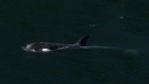
Orca calf that was trapped in B.C. lagoon for weeks swims free
An orca whale calf that has been stranded in a B.C. lagoon for weeks after her pregnant mother died swam out on her own early Friday morning.
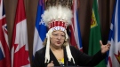
'Unacceptable': Trudeau reacts after AFN chief says headdress taken from plane cabin
After the Assembly of First Nations' national chief said her headdress was taken from an airplane cabin this week, Prime Minister Justin Trudeau called the incident 'unacceptable' and a 'mistake' on the part of Air Canada.
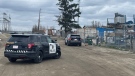
Regina police officer injured after being accidentally shot by fellow officer's gun
An investigation is underway after a Regina police officer was accidentally shot by a fellow officer’s gun during the search of a house early Friday morning.
Sophie Gregoire Trudeau on navigating post-political life, co-parenting and freedom
Sophie Gregoire Trudeau says there is 'still so much love' between her and Prime Minister Justin Trudeau, as they navigate their post-separation relationship co-parenting their three children.
DEVELOPING
DEVELOPING Bird flu outbreaks: WHO weighs in on public health risk
The current overall public health risk posed by the H5N1 bird flu virus is low, the World Health Organization said on Friday, but urged countries to stay alert for cases of animal-to-human transmission.
Taylor Swift dons Montreal designer's dress in 'Fortnight' video
A pair of Montreal designers' work has now been viewed over 41 million times. Taylor Swift dons a Victorian throwback black gown in her latest music video, 'Fortnight', designed by UNTTLD due Simon Belanger and Jose Manuel Saint-Jacques.
From faulty kids' cribs to flammable kids' bathrobes, here are the recalls of the week
Health Canada issued recalls for various items this week, including kids’ bathrobes, cribs and henna cones.
Island near Mull of Kintyre for sale for US$3.1 million
An idyllic 453-acre private island is up for sale off the west coast of Scotland and it comes with sandy beaches, puffins galore, seven houses, a pub, a helipad and a flock of black-faced sheep.
Shopping Trends
The Shopping Trends team is independent of the journalists at CTV News. We may earn a commission when you use our links to shop. Read about us.


Regina
-

Regina police officer injured after being accidentally shot by fellow officer's gun
An investigation is underway after a Regina police officer was accidentally shot by a fellow officer’s gun during the search of a house early Friday morning.
-
Inquest for Regina teen found unresponsive in creek 9 years ago set for May
A public inquest into the death of a Saskatchewan teenager who was found unresponsive in a creek east of Regina in 2015 will take place in May.
-
Sask. RCMP make 2 arrests in connection to Oxbow area homicide
RCMP have made two arrests in connection to a homicide investigation in southeast Saskatchewan.
Saskatoon
-

Blades, Warriors prepare for first all Sask. conference final in 31 years
For the first time since 1993 two Saskatchewan teams will face each other in the Western Hockey League’s (WHL) Eastern Conference Final as the Moose Jaw Warriors and Saskatoon Blades get their third round series underway Friday night
-
Four people arrested after attempted armed robbery in Saskatoon
Four people, including two teen girls, were arrested and charged after an attempted armed robbery on Thursday evening.
-
Council votes for bike safety improvements at corner where cyclist was killed
Saskatoon city council is making road safety improvements following the death of a cyclist at a busy intersection last year.
Edmonton
-

Child sexual exploitation charges laid against Alberta RCMP officer
An Alberta RCMP officer has been charged with child sexual exploitation offences.
-
Artistic Oilers fans churning out best work during motivating playoff run
The Edmonton Oilers' playoff run is inspiring the team's most creative fans.
-
Skinner has confidence of his coach, but playoff goaltending a concern for Oilers
Skinner has confidence of his coach, but playoff goaltending a concern for Oilers
Calgary
-
Calgary police investigate shooting in Valleyfield industrial area
Calgary police are investigating a shooting reported in the Valleyfield industrial area on Friday.
-
Calgary man sentenced to 30 months after downtown stabbing spree
A Calgary man has been sentenced to 30 months in prison for his role in a downtown stabbing spree last year that sent multiple people to hospital.
-
Parade of Wonders returns to Calgary, thousands expected to participate
Canada's largest cosplay parade is back in full force, returning to city for the 10th time on Friday.
Toronto
-

'Extremely traumatizing:' Boy, 11, struck by transport truck in Etobicoke
An 11-year-old boy struck by a transport truck in Etobicoke on Friday morning suffered critical injuries and is receiving treatment at a Toronto trauma centre, police say.
-
'I was scared': Ontario man's car repossessed after missing two repair loan payments
An Ontario man who took out a loan to pay for auto repairs said his car was repossessed after he missed two payments.
-
Man seriously injured on Toronto subway tracks while fleeing police: TPS
A man has been transported to hospital in serious condition after police say he jumped on the subway tracks at Sherbourne Station while attempting to flee from officers.
Ottawa
-

'Too young to have breast cancer': Rates among young Canadian women rising
Breast cancer rates are rising in Canada among women in their 20s, 30s and 40s, according to research by the University of Ottawa (uOttawa).
-
Queen’s University names award-winning journalist Shelagh Rogers as next chancellor
Queen’s University says renowned Canadian broadcaster and alumna, Shelagh Rogers will serve as its 16th chancellor starting July 1.
-
Flood watch in effect along areas of Ottawa River until May 3
The Ministry of Natural Resources and Forestry has issued a flood watch for the Pembroke, Ont. area.
Montreal
-

Body of Quebec man who died in Cuba found in Russia, family confirms
A Montreal-area family confirmed to CTV News that the body of their loved one who died while on vacation in Cuba is being repatriated to Canada after it was mistakenly sent to Russia.
-
Taylor Swift dons Montreal designer's dress in 'Fortnight' video
A pair of Montreal designers' work has now been viewed over 41 million times. Taylor Swift dons a Victorian throwback black gown in her latest music video, 'Fortnight', designed by UNTTLD due Simon Belanger and Jose Manuel Saint-Jacques.
-
Cars to go extinct at Parc Safari, wildlife park to use electric trucks
After more than 50 years, the Parc Safari wildlife park is going car-free for the 2024 season, instead offering visitors rides on electric trucks in its famous Safari Adventure site.
Atlantic
-

First court appearance for boy and girl charged in death of Halifax 16-year-old
A girl and a boy, both 14 years old, made their first appearance today in a Halifax courtroom, where they each face a second-degree murder charge in the stabbing death of a 16-year-old high school student.
-
Friday morning fire destroys 130-year-old church in Bridgetown, N.S.
A church in Bridgetown, N.S., has been destroyed by a Friday morning fire.
-
BREAKING
BREAKING King Charles' cancer treatment progressing well, says Buckingham Palace
King Charles III’s doctors are 'sufficiently pleased' with his cancer treatment and he is expected to return to public-facing duties, Buckingham Palace announced on Friday.
Vancouver
-
Orca calf that was trapped in B.C. lagoon for weeks swims free
An orca whale calf that has been stranded in a B.C. lagoon for weeks after her pregnant mother died swam out on her own early Friday morning.
-
Vancouver police seek witnesses after crash leaves man with life-threatening injuries
Police in Vancouver are appealing for witnesses to come forward after a serious crash Thursday left one man in hospital with life-threatening injuries.
-
Infertility Awareness Week: How B.C.'s proposed IVF funding is delaying some treatments
It’s National Infertility Awareness week, which brings attention to a medical condition that impacts one-in-six adults in B.C.
Vancouver Island
-
Orca calf that was trapped in B.C. lagoon for weeks swims free
An orca whale calf that has been stranded in a B.C. lagoon for weeks after her pregnant mother died swam out on her own early Friday morning.
-
Opposition BC United seeks to prevent convicted dangerous offenders from name changes
British Columbia's Opposition leader says community safety should come before protection of privacy rights for dangerous people.
-
'Violation': CSIS had officer investigated after she reported a superior raped her
A CSIS officer's allegations that she was raped repeatedly by a superior in agency vehicles set off a harassment inquiry, but also triggered an investigation into her that concluded the alleged attacks were a “misuse” of agency vehicles by the woman.
Kelowna
-

B.C. man rescues starving dachshund trapped in carrier: BC SPCA
An emaciated dachshund is now recovering thanks to a Good Samaritan who found the pup near a biking trail in Kelowna, according to the BC SPCA.
-
Search crews called in after missing Kelowna senior's truck found
Search and rescue crews have been called in after a vehicle belonging to a missing senior was located near a rural intersection outside of Kelowna Tuesday.
-
Homicide investigation underway after body found near Kelowna, B.C.
Major crime detectives in British Columbia are investigating a suspected homicide after a body was found in a remote area southeast Kelowna over the weekend.
N.L.
-

Voice of 'Hockey Night in Canada' Bob Cole never considered moving out of St. John's
Legendary sportscaster Bob Cole was a Newfoundlander through and through, and his daughter says his connection to the province was 'everything' to him.
-
Cenovus fined $2.5 million for biggest oil spill in Newfoundland and Labrador history
Cenovus Energy has been ordered to pay a $2.5-million fine for its role in the largest offshore oil spill ever recorded in Newfoundland and Labrador.
-
Canada recognizes housing as a human right. Few provinces have followed suit
As more Canadians find themselves struggling to afford or find housing, the country's smallest province is the only one that can point to legislation recognizing housing as a human right.
Northern Ontario
-

Northern Ont. hunters fined $8,500 for illegal moose hunt
Two hunters from North Bay, Ont., and a third from Temagami pled guilty recently to offences they committed during a 2022 moose hunt.
-
Fire victims in Timmins say thieves have stolen their personal belongings
A month after an accidental fire forced more than 100 people out of their apartments at the Empire Complex in Timmins, residents are now dealing with being victims of theft.
-
'Too young to have breast cancer': Rates among young Canadian women rising
Breast cancer rates are rising in Canada among women in their 20s, 30s and 40s, according to research by the University of Ottawa (uOttawa).
Barrie
-

Pedestrian struck by CP train in Alliston
A man is in serious condition after being struck by a train near Alliston.
-
Police warn of caller ID phone scams
Faking a caller identity has never been so easy.
-
Garage fire sends resident to hospital
A small garage fire sent a resident to the hospital in Huntsville.
Kitchener
-

Police investigate Cambridge hit-and-run involving pedestrian
Waterloo regional police is investigating a hit-and-run collision involving a pedestrian on Dunbar Road at Briarwood Drive in Cambridge.
-
Driver hits woman pushing 3-month-old baby in stroller
An elderly Guelph driver has been charged after hitting a woman pushing a stroller.
-
Another fire at old Robson Lang building in Kitchener
Flames could be seen coming from a vacant leather factory in Kitchener once again late Thursday night.
London
-

Portion of Highway 401 reopens following fatal crash
A fatal crash in Thames Centre closed down a portion of Highway 401 westbound. Around 2:15 a.m., first responders were called to westbound lanes of the highway between Culloden and Putnam Roads for a two-vehicle crash.
-
Two people taken to hospital after Oxford County crash
An unknown number of people have been taken to hospital following a crash in Oxford County. OPP are on scene of the two-vehicle crash at 37th Line and Road 74 in Zorra.
-
London police searching for shopping centre arson suspects
London police are asking for the public's help locating four suspects in an arson investigation.


