Colorado Low dousing parts of Manitoba with ‘mixed bag’ of precipitation
A Colorado Low that moved into parts of Manitoba overnight continues to bring heavy snow and rain to parts of the province Thursday.
Environment and Climate Change Canada (ECCC) has issued snowfall warnings for parts of southwestern Manitoba, including Brandon, Dauphin and Riding Mountain National Park.
The weather agency says another four to eight centimetres is expected to fall today in parts of the southwest, with the highest amounts expected over the high terrain of the west near the Riding Mountains.
Snow is expected to taper off overnight Thursday and into Friday.
Meantime, the system is likely to encroach on the rest of southern Manitoba.
Areas like Winnipeg, Portage la Prairie and Swan River are currently under a special weather statement, which notes precipitation will continue as rain or drizzle in the Red River Valley and southeastern Manitoba.
As the system moves east on Thursday afternoon, precipitation is expected to change from rain to snow.
A snowfall warning is in effect for the highlighted region(s) below. Details: https://t.co/jFJeUCfVx9 #mbstorm pic.twitter.com/sbjqh38OUU
— CTV News Winnipeg (@ctvwinnipeg) February 8, 2024
Snow is likely to continue until Friday morning.
About five to 10 millimetres of rain is possible in southeast Manitoba, and snowfall accumulations are expected to be about two to six centimetres.
A return to colder, yet still above seasonal temperatures, is forecast for the weekend and into next week.


CTVNews.ca Top Stories

Ontario to ban use of cellphones in school classrooms starting in September
Ontario is introducing a suite of measures that will crack down on cellphone use and vaping in schools.
Here's where Canadians are living abroad: report
A recent report sheds light on Canadians living abroad--estimated at around four million people in 2016—and the public policies that impact them.
Kitchener family says their 10-year-old needs life-saving drug that cost $600,000
Raneem, 10, lives with a neurological condition and liver disease and needs Cholbam, a medication, for a longer and healthier life.
Invasive and toxic hammerhead worms make themselves at home in Ontario
Ontario is now home to an invasive and toxic worm species that can grow up to three feet long and can be dangerous to small animals and pets.
Laurentian University to spend millions on recommendations in second budget post insolvency, but nothing new to reopen pool
Laurentian University's board of governors approved a budget of just over $201.7 million for the 2024-2025 fiscal year.
Murder charge laid after man falls to death from Toronto apartment balcony
One person has been charged with second-degree murder in connection with the death of a man who fell from a balcony following an altercation inside a Toronto apartment building.
Dozens in Italy give a fascist salute on the anniversary of Mussolini's execution
Dozens of people raised their arms in the fascist salute and shouted a fascist chant during ceremonies Sunday to honor Italian dictator Benito Mussolini on the 79th anniversary of his execution.
'Do not consume': Gift Chocolate recalled due to undeclared milk, soy
The Canadian Food Inspection Agency has issued a recall for a specific chocolate brand sold in Ontario and Quebec.
Zendaya tennis movie ‘Challengers’ scores at weekend box office
Zendaya and castmates Mike Faist and Josh O’Connor have been on a globetrotting press tour to get the word out about Italian director Luca Guadagnino's original film, which opened in 3,477 locations in the U.S. and Canada.
Shopping Trends
The Shopping Trends team is independent of the journalists at CTV News. We may earn a commission when you use our links to shop. Read about us.


Regina
-

Regina Rebels beat out North York Storm to win team's first ever Esso Cup
The Regina Rebels made history over the weekend — taking home gold for the first time ever at the U18 women's hockey national championships.
-
No injuries reported after fire causes significant damage to North Central home
Regina's fire service is investigating following a significant house fire in the North Central area.
-
Regina's Dunlop Art Gallery welcomes new installation
'Feel through the Deepness to see,' an art installation by artist Rita McKeough, will be calling the Dunlop Art Gallery home for the next two months.
Saskatoon
-

Saskatoon care home workers escalating strike action
Workers at group homes run by LutherCare Communities in Saskatoon are escalating their strike action.
-
Saskatoon Indigenous and Palestinian communities gather in collective prayer for Gaza
On Saturday, in a display of cross-cultural solidarity, members of the Indigenous and Palestinian communities gathered in Saskatoon for an event steeped in prayer and dance.
-
Saskatoon police investigating after body found at recycling facility
The Saskatoon Police Service (SPS) and Saskatchewan Coroners Service are investigating after a woman’s body was found at a recycling facility Friday morning.
Edmonton
-

Man dead after motorcycle crash on Highway 16 Saturday
A man is dead after he reportedly lost control of his motorcycle in Strathcona County Saturday night.
-
Woman killed in crash near Fort McMurray International Airport Saturday morning
A woman was killed after crashing into a water truck near the Fort McMurray International Airport Saturday morning.
-
Oilers coach calls McDavid and Draisaitl’s playoff performances remarkable
Kris Knoblauch is five months into watching Connor McDavid and Leon Draisaitl go to work.
Calgary
-

Pedestrian suffers ‘life-altering’ injuries after getting run over twice in Bridgeland parking lot
Calgary police are investigating after a hit-and-run Saturday afternoon in Bridgeland that left a pedestrian hospitalized with serious, life-altering injuries.
-
Man in serious but non-life-threatening condition following Saddle Ridge hit-and-run
An investigation is underway after a pedestrian was struck and dragged by a vehicle early Sunday morning.
-
Family arrives safely in Calgary after escaping the war in Gaza
It was a long-awaited reunion at the Calgary International Airport Saturday as Ossama Zaqqout hugged his parents, who had just arrived after fleeing the war in Gaza.
Toronto
-
Ontario to ban use of cellphones in school classrooms starting in September
Ontario is introducing a suite of measures that will crack down on cellphone use and vaping in schools.
-
BOS LEADS TOR 3-1
BOS LEADS TOR 3-1 Marchand stars again, Swayman solid as Bruins push frustrated Leafs to the brink
Brad Marchand became the Bruins' all-time leading playoff goal-scorer and added an assist as Boston suffocated the Toronto Maple Leafs 3-1 on Saturday to take a 3-1 lead in the teams' first-round playoff series.
-
Invasive and toxic hammerhead worms make themselves at home in Ontario
Ontario is now home to an invasive and toxic worm species that can grow up to three feet long and can be dangerous to small animals and pets.
Ottawa
-
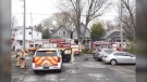
Vanier home fire displaces 2 adults, firefighters say
The Ottawa Fire Services says two residents have been displaced following a fire that happened in the second floor of a two-storey double home in Vanier.
-
'Do not consume': Gift Chocolate recalled due to undeclared milk, soy
The Canadian Food Inspection Agency has issued a recall for a specific chocolate brand sold in Ontario and Quebec.
-
Text messages asking to pay speeding tickets scam, City of Ottawa warns
The City of Ottawa is warning people of a new scam asking residents to make payments by text messages.
Montreal
-
Quebec to invest $603 million to protect the French language
Quebec is investing $603 million over the next five years to counter what its French-language minister describes as the decline of the French language in the province.
-
Quebec singing star and cultural icon Jean-Pierre Ferland dies at 89
Quebec singing star and cultural icon Jean-Pierre Ferland died on Saturday at the age of 89.
-
Quebec liquor board to cull spirits from shelves as local distillers struggle
The number of microdistilleries in Quebec has boomed in the last decade, growing from less than a dozen to about 70.
Atlantic
-
Health minister 'deeply appreciative' of doctors but capital gains changes here to stay
Health Minister Mark Holland says while he is 'deeply appreciative' of the work doctors in Canada do, the federal government has no plans to scrap the proposed capital gains tax changes outlined in the latest budget, despite opposition from the Canadian Medical Association.
-
Bidders express interest in buying all or part of SaltWire newspaper business
A Toronto-based restructuring firm says several bidders have offered to buy all or part of SaltWire Network and The Halifax Herald, the two insolvent companies that operate Atlantic Canada's largest newspaper enterprise.
-
Halifax Wanderers kick off season with home opener against Ottawa
Halifax’s professional soccer team kicks off its sixth season against Ottawa on Saturday with a sold-out crowd of 6,500 fans on the Wanderers Grounds.
Vancouver
-

Woman found dead, son arrested in Richmond: IHIT
A woman was found dead in her home in Richmond on Friday and her son was arrested at the scene, police say.
-
Wrong-way driver causes crash on Highway 99: Surrey RCMP
A crash on Highway 99 Sunday morning was caused by a driver going the wrong way on Highway 99, according to authorities.
-
Vancouver is one step closer to getting a Filipino cultural centre, society says
As the Lower Mainland's Filipino community gathered in South Vancouver for Lapu-Lapu Day on Saturday, one of the festival's organizers set its sights on creating a future focal point for such gatherings.
Vancouver Island
-

B.C. breweries take home awards at World Beer Cup
Out of more than 9,000 entries from over 2,000 breweries in 50 countries, a handful of B.C. brews landed on the podium at the World Beer Cup this week.
-
Canucks defeat Predators in Game 3, take 2-1 series lead
J.T. Miller had a goal and assist and the Vancouver Canucks edged the Nashville Predators 2-1 to re-take the lead in their first-round playoff series.
-
Haida Elder suing Catholic Church and priest, hopes for 'healing and reconciliation'
The lawyer for a residential school survivor leading a proposed class-action defamation lawsuit against the Catholic Church over residential schools says the court action is a last resort.
Kelowna
-
B.C. breweries take home awards at World Beer Cup
Out of more than 9,000 entries from over 2,000 breweries in 50 countries, a handful of B.C. brews landed on the podium at the World Beer Cup this week.
-
B.C. man rescues starving dachshund trapped in carrier: BC SPCA
An emaciated dachshund is now recovering thanks to a Good Samaritan who found the pup near a biking trail in Kelowna, according to the BC SPCA.
-
Search crews called in after missing Kelowna senior's truck found
Search and rescue crews have been called in after a vehicle belonging to a missing senior was located near a rural intersection outside of Kelowna Tuesday.
N.L.
-

Voice of 'Hockey Night in Canada' Bob Cole never considered moving out of St. John's
Legendary sportscaster Bob Cole was a Newfoundlander through and through, and his daughter says his connection to the province was 'everything' to him.
-
Cenovus fined $2.5 million for biggest oil spill in Newfoundland and Labrador history
Cenovus Energy has been ordered to pay a $2.5-million fine for its role in the largest offshore oil spill ever recorded in Newfoundland and Labrador.
-
Canada recognizes housing as a human right. Few provinces have followed suit
As more Canadians find themselves struggling to afford or find housing, the country's smallest province is the only one that can point to legislation recognizing housing as a human right.
Northern Ontario
-

Laurentian University to spend millions on recommendations in second budget post insolvency, but nothing new to reopen pool
Laurentian University's board of governors approved a budget of just over $201.7 million for the 2024-2025 fiscal year.
-
Ontario to ban use of cellphones in school classrooms starting in September
Ontario is introducing a suite of measures that will crack down on cellphone use and vaping in schools.
-
Thunderstorm watches lifted in northeastern Ont., new special weather statements issued for freezing rain
Environment Canada has lifted the thunderstorm watches issued on Saturday for northeastern Ontario – however, has since issued special weather statements warning of freezing rain from Chapleau, Ont. to Sturgeon Lake, Ont. beginning Monday.
Barrie
-
Orillia marks annual Day of Mourning to remember lives lost, injured at work
A solemn occasion to mark the lives lost and workers injured on the job took place in Orillia on Sunday.
-
Police searching for man on Lake Muskoka after possible drowning call
Police and search and rescue crews in Gravenhurst are trying to locate a man after reports of a possible drowning.
-
Deadly six-vehicle crash on Highway 400 sparked by road rage incident
One person was killed in a six-vehicle crash on Highway 400 in Innisfil Friday evening.
Kitchener
-

Most-read stories of the week: Stolen laptop, parking dispute, $0.05 property tax bill
A ransom for a stolen laptop, a parking dispute at a Kitchener apartment building, and a five-cent property tax bill round out the most-read stories of the week.
-
Kitchener family says their 10-year-old needs life-saving drug that cost $600,000
Raneem, 10, lives with a neurological condition and liver disease and needs Cholbam, a medication, for a longer and healthier life.
-
Man found unconscious and seriously hurt in Kitchener parking lot, police investigating
Waterloo regional police are investigating after they found a man unconscious in a Kitchener parking lot with serious injuries.
London
-
Ontario to ban use of cellphones in school classrooms starting in September
Ontario is introducing a suite of measures that will crack down on cellphone use and vaping in schools.
-
5 people 'narrowly' escape residence during early morning fire
Working smoke alarms and an alert passerby are credited with saving the lives of several people after a fire broke out at a home in the city’s south end early Sunday morning.
-
Mathyssen says Liberals need to make good on housing promises in federal budget
While the federal NDP said it has not decided whether it will support the Liberals’ federal budget tabled this week, London Fanshawe New Democrat MP Lindsay Mathyssen said the party needs to see more.


