The operation of the Red River Floodway means fewer homes in Winnipeg require sandbags than originally estimated.
The City of Winnipeg had said on Thursday that as many as 50 homes were at risk of flooding and on Friday, the province lifted the floodway.
On Saturday, the city said 25 homes need sandbags dikes now as a precaution. The city has asked the owners of the other 25 properties to remain on standby.
The Red River is expected to peak in Winnipeg on Sunday. The city estimated the river would peak between 18.6 and 20.8 feet at the James Avenue station.
Saturday afternoon, the province reported the water level at the James station was 19.4 feet, an increase of 1.2 feet overnight.
The province said the rise was due to an upstream ice run that created a flow surge downstream.
“There are still some ice pans that are moving through the system which also sometimes can influence river levels to climb to some degree and then we see them fall in a relatively short order of time,” said Chris Carroll of the City of Winnipeg Water and Waste Department.
READ MORE: Winnipeg scaling back flood preparations as floodway operations begin
With the floodway in operation, the province expects the Red River to decline to about 19 feet by Sunday.
The number of properties at risk could change, depending on ice conditions and whether any rain or snow falls in the next few days, the city said.
The city said it has enough sandbags to meet the current need and crews continue to make more.
“It’s really the sandbag dikes that need to be constructed still today. They’re smaller dikes, they require fewer sandbags, so we’re very confident that those property owners will be able to build them today and get them in place,” said Ken Allen of the Public Works Department.
If a property owner hasn’t been contacted by the city but believes their property is at risk, call 311 or email 311@winnipeg.ca.
#RedRiver up to the walking trail at King's Park in South #Winnipeg #mbflood @weathernetwork @CBCManitoba pic.twitter.com/n8yYgWlNfl
— Joel Allen (@jallen_wx) April 1, 2017
In the south of the city, the Red River overflowed its banks in King’s Park near the University of Manitoba.
The Assiniboine River also overflowed its banks and flooded this parking lot on Roslyn Road in Winnipeg on Saturday. The Portage Diversion began operation on Friday in an effort to limit flows on the lower Assiniboine and prevent ice jamming.
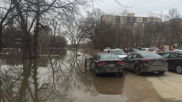
The Assiniboine River overflowed its banks and flooded this parking lot on Roslyn Road in Winnipeg on Saturday, April 1, 2017. (Photo: Twitter/@icedkarma1)
READ MORE: Overland flooding prompts state of emergency in southern Manitoba
Several areas of the province are under flood watches and warnings. High water advisories are in effect for Overflowing, Valley and Vermillion rivers.
Flood watches are in effect for Turtle, Woody, Swan, Whitemud and Red Deer rivers.
Flood warnings are in effect for Fisher, Morris and Pembina rivers, as well as Pipestone Creek.
The province said it expects Highway 75 to remain open.


