Potential for baseball-sized hail as severe thunderstorm warnings hit Manitoba
 Some parts of the province can expect to see baseball-sized hail Saturday, as more thunderstorms roll into southern Manitoba. (Photo submitted by Jodi Stewart)
Environment and Climate Change Canada (ECCC) have issued several severe thunderstorm warnings and watches for southern parts of the province.
A warning is in effect for the RMs of Armstrong, and Victoria, as well as the municipalities of Norfolk Treherne and North Norfolk.
According to ECCC meteorologist Justin Shaer, a storm heading toward Austin, Man., could produce baseball-sized hail.
“We received a report of (golf ball-sized) hail so far, but by all indications, there’s much larger hail within this thunderstorm,” Shaer told CTV News.
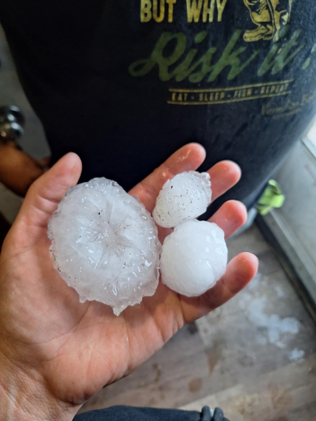 Large hail fell near Edrans, Man., Saturday. (Photo submitted by Jodi Stewart)
Earlier Saturday, ECCC reported wind gusts of up to 106 km/h in the Austin area, while Oak Bluff, Man., received loonie-sized hail.
A tornado warning was in effect in Manitoba's Interlake region, but has since been downgraded.
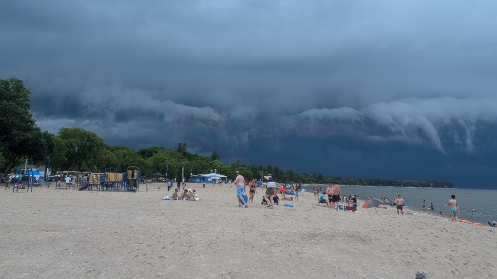 A tornado warning was in effect for the province's Interlake region, including Gimli, Man., but now a severe thunderstorm watch is in place. (Photo submitted by Diane Carriere)
A severe thunderstorm watch is in effect for Winnipeg, and stretches from Saskatchewan Point all the way to Emerson, near the U.S. border.
Shaer also said the heat and humidity are contributing to the risk of thunderstorms Saturday afternoon.
“We could see some activity over western Manitoba and that could roll into the Red River Valley in Winnipeg in the overnight hours and early Monday morning hours as well,” Shaer said.
ECCC recommends people stay up to date on the latest forecast, along with watches and warnings.
Shopping Trends
The Shopping Trends team is independent of the journalists at CTV News. We may earn a commission when you use our links to shop. Read about us.


CTVNews.ca Top Stories

Trudeau appears unwilling to expand proposed rebate, despite pressure to include seniors
Prime Minister Justin Trudeau does not appear willing to budge on his plan to send a $250 rebate to 'hardworking Canadians,' despite pressure from the opposition to give the money to seniors and people who are not able to work.
'Mayday!': New details emerge after Boeing plane makes emergency landing at Mirabel airport
New details suggest that there were communication issues between the pilots of a charter flight and the control tower at Montreal's Mirabel airport when a Boeing 737 made an emergency landing on Wednesday.
Cucumbers sold in Ontario, other provinces recalled over possible salmonella contamination
A U.S. company is recalling cucumbers sold in Ontario and other Canadian provinces due to possible salmonella contamination.
Trudeau says no question incoming U.S. president Trump is serious on tariff threat
Prime Minister Justin Trudeau says incoming U.S. president Donald Trump's threats on tariffs should be taken seriously.
Latest updates: Tracking RSV, influenza, COVID-19 in Canada
As the country heads into the worst time of year for respiratory infections, the Canadian respiratory virus surveillance report tracks how prevalent certain viruses are each week and how the trends are changing week to week.
Weekend weather: Parts of Canada could see up to 50 centimetres of snow, wind chills of -40
Winter is less than a month away, but parts of Canada are already projected to see winter-like weather.
Atlantic hurricane season comes to an end, leaving widespread damage in its wake in U.S.
The 2024 Atlantic hurricane season comes to a close Saturday, bringing to an end a season that saw 11 hurricanes compared to the average seven.
Armed men in speedboats make off with women and children when a migrants' dinghy deflates off Libya
Armed men in two speedboats took off with women and children after a rubber dinghy carrying some 112 migrants seeking to cross the Mediterranean Sea started deflating off Libya's coast, a humanitarian aid group said Friday.
Federal government posts $13B deficit in first half of the fiscal year
The Finance Department says the federal deficit was $13 billion between April and September.
Regina
-

Jury sequestered to find verdict in sexual assault trial against Regina chiropractor
Justice Janet McMurtry sequestered a 12-person jury to determine a verdict against Regina-based chiropractor Ruben Manz.
-
Here's how thick ice needs to be to park a truck on it, according to Sask. Water Security Agency
The Saskatchewan Water Security Agency (WSA) says ice should be at least one foot (30 centimetres) thick before it's safe to drive a car or light truck on a frozen body of water.
-
Fundraising campaign at Regina school ends with an alpaca kiss
Students, staff and family members of Imperial Community School gathered to celebrate a successful fundraising campaign for United Way Regina.
Saskatoon
-

'A huge value addition': Sask. scientists develop way to make canola meal more profitable
Researchers at the University of Saskatchewan are looking at making the canola crop more profitable.
-
'Due to the temperatures, we are concerned': RCMP seek tips finding missing elderly man
Saskatchewan RCMP are asking property owners in the rural area in the RM of Laird to check farm outbuildings or sheds in their area for a missing 60-year-old man.
-
Ontario men arrested after Saskatoon police seize 16 kilos of meth, nearly $70K in cash
Saskatoon police say officers arrested three 20-year-old men Wednesday afternoon and seized nearly $70,000, in cash as well as various illicit drugs.
Edmonton
-

Machete used to kill Edmonton man may have been picked up by passerby: police
Police are searching for the weapon used to kill an Edmonton man last month.
-
Pedestrian hospitalized after Friday morning crash in central Edmonton
A woman is in hospital with serious injuries after a crash on Friday morning.
-
If you live in St. Albert this is how you can send a letter to Santa during the postal strike
St. Albert children looking to send letters to Santa Claus during the Canada Post strike have several options this holiday season.
Calgary
-

Calgary fighters thankful to enter ring under safe conditions after Ultra Boxing event cancelled
A group of Calgary fighters are thankful to be able to enter the ring under a properly sanctioned event this weekend after the organization they were training under was suspended by Boxing Alberta for two years due to safety concerns.
-
Calgary Mayor Jyoti Gondek running for re-election
Calgary Mayor Jyoti Gondek has announced she will run for re-election in the next municipal election in 2025.
-
Cucumbers sold in Ontario, other provinces recalled over possible salmonella contamination
A U.S. company is recalling cucumbers sold in Ontario and other Canadian provinces due to possible salmonella contamination.
Toronto
-
 BREAKING
BREAKING Feds announce $758 million in funding for new Line 2 TTC subway trains
The TTC will get funding from the federal government to replace aging trains on Line 2, Deputy Prime Minister Chrystia Freeland has announced.
-
Highway 407 owner says no active buyback discussions with Ontario government
The provincial government is facing increasing pressure to tap into the underused and tolled Highway 407 to alleviate congestion on Highway 401.
-
Cucumbers sold in Ontario, other provinces recalled over possible salmonella contamination
A U.S. company is recalling cucumbers sold in Ontario and other Canadian provinces due to possible salmonella contamination.
Ottawa
-

Next big test for the LRT south extension taking place Saturday
Five hundred people will be riding on Lines 2 and 4 Saturday, to simulate passenger service in a 'dress rehearsal' that marks the next major step before the delayed south extension can open to the public.
-
Ottawa police charge two adults, teenager following Orleans kidnapping and robbery
The Ottawa Police Service says two adults and a teenager are facing multiple charges following a kidnapping, robbery and extortion incident that happened last month in Orleans.
-
'Dude, Where's My Bus?' Ottawa man fed up with OC Transpo makes documentary exploring transit troubles
Gio Petti put together a documentary on OC Transpo, asking how we got here. How did a city that was once lauded as an example of how to do transit right, and that boasted some of the highest per capita transit ridership numbers in the country, become a system that now elicits so much frustration from users?
Montreal
-

Quebec trying to 'minimize' impact of health care cuts on services
Eliminating $1.5 billion in health care spending is likely to have an impact on services, but Quebec says it will try to 'minimize' it.
-
One woman killed, one hurt in armed robbery attempt southeast of Quebec City
A woman was killed and another badly injured after an armed robbery attempt at a clothing store in St-Anselme, Que., according to Quebec provincial police.
-
'Mayday!': New details emerge after Boeing plane makes emergency landing at Mirabel airport
New details suggest that there were communication issues between the pilots of a charter flight and the control tower at Montreal's Mirabel airport when a Boeing 737 made an emergency landing on Wednesday.
Atlantic
-

Suspect taken into custody after weapons complaint at Halifax high school
A suspect has been taken into custody after a high school in Halifax was placed in hold and secure Friday morning.
-
Teen arrested in connection with weapons call at Fredericton High School
Fredericton Police Force arrested a 14-year-old boy Thursday in relation to a weapons call at Fredericton High School.
-
Some closures, power outages in the Maritimes with first storm of the winter season
Parts of the Maritimes are experiencing their first winter storm on Friday with a messy weather system moving north from the eastern U.S.
Vancouver
-

Study of 2023 Okanagan wildfires recommends limiting development in high-risk areas
A study into the devastating wildfires that struck British Columbia's Okanagan region in 2023 has recommended that government and industry limit development in high-fire-risk areas.
-
Man facing 10 charges after Richmond, B.C., crime spree
A Metro Vancouver man has been charged with nine counts of breaking and entering and one count of mischief after a five-day crime spree last November.
-
Vancouver Canucks defenceman Hronek being evaluated for undisclosed injury
Vancouver Canucks defenceman Filip Hronek has been sidelined by an undisclosed injury.
Vancouver Island
-

Winter storm watch issued as snow, heavy rain expected for B.C. coast
A winter storm is moving over British Columbia's coast, bringing strong winds, heavy snow and freezing rain as snowfall warnings continue for much of the province's Interior.
-
Police renew appeal for information 12 years after Victoria woman's disappearance
On the anniversary of her disappearance, police in Victoria renewed their appeal for information in Emma Fillipoff’s 12-year-old missing persons case.
-
Man facing 10 charges after Richmond, B.C., crime spree
A Metro Vancouver man has been charged with nine counts of breaking and entering and one count of mischief after a five-day crime spree last November.
Kelowna
-
Study of 2023 Okanagan wildfires recommends limiting development in high-risk areas
A study into the devastating wildfires that struck British Columbia's Okanagan region in 2023 has recommended that government and industry limit development in high-fire-risk areas.
-
Kelowna, B.C., to host the Memorial Cup in the spring of 2026
The Western Hockey League's Kelowna Rockets will host the Memorial Cup in the spring of 2026, the Canadian Hockey League said Wednesday.
-
545 vehicles impounded in 332 days: BC Highway Patrol pleads for drivers to slow down
Mounties with the BC Highway Patrol in Kelowna say they've impounded more than 545 vehicles for excessive speed and aggressive driving so far this year. That works out to more than 1.6 per day.
N.L.
-

Newfoundland's LGBTQ2S+ bar paid drag queens $37.50. Tara Nova called them out.
If the screaming crowd in the twinkling Majestic Theatre in downtown St. John's was any indication, Newfoundland drag queen Tara Nova will never have to accept $37.50 for a show again.
-
'Who profits on hunger?': Inuit send pleading emails to minister about food costs
People in Nunavut and northern Labrador have been writing to Canadian government officials this year to say grocers were charging exorbitant prices despite receiving a federal subsidy.
-
As N.L. firm pivots, scientists say Canada's green hydrogen dreams are far-fetched
A Newfoundland energy company's embrace of data centres is raising doubts about eastern Canadian hopes of harnessing the region's howling winds to supply Germany with power from green hydrogen.
Northern Ontario
-

Man fined $10K for abandoning homemade barge in Lake Nipissing
A man from Lavigne, Ont., has been fined $10,000 for abandoning a homemade barge in Lake Nipissing.
-
Another 60 cm of snow possible in the Sault as severe weather continues
Closures and cancellations are piling up in Sault Ste. Marie as a major winter storm continues for another day Friday.
-
California man who went missing for 25 years found after sister sees his picture in the news
It’s a Thanksgiving miracle for one California family after a man who went missing in 1999 was found 25 years later when his sister saw a photo of him in an online article, authorities said.
Barrie
-

50 cm of snow across central Ontario expected this weekend
Environment Canada has released snow squall warnings and watches for our region.
-
Alleged mastermind behind Ontario woman's presumed death seeks bail
The man facing first-degree murder and kidnapping charges in the disappearance of Ontario woman Elnaz Hajtamiri took another shot at bail on Friday in a Barrie courtroom. Mohamad Lilo, 37, has been behind bars since his arrest more than two years ago.
-
Two men charged with assaulting municipal law enforcement officer, one suspect at large
Two people face charges as police seek a third individual in connection with the alleged assault of a municipal law enforcement officer.
Kitchener
-

Erick Buhr to represent himself during sentencing for second-degree murder in death of his grandmother, Viola Erb
Erick Buhr will represent himself as he prepares for sentencing after being convicted of second-degree murder in the death of his grandmother, Viola Erb.
-
Man accused of involvement in massive data breach appears in Kitchener court
The man accused of being behind a massive data breach impacting several large U.S. companies made a brief appearance in Kitchener court Friday.
-
Cucumbers sold in Ontario, other provinces recalled over possible salmonella contamination
A U.S. company is recalling cucumbers sold in Ontario and other Canadian provinces due to possible salmonella contamination.
London
-

Crown witness describes chaotic night after bush party shooting
Crown witness Reece Davidson, 21, told the jury that he was at the bush bash off of Pack Road in southwest London with a bunch of his young friends on July 30, 2021.
-
Employees pepper sprayed at London business
Around 4 p.m. on Thursday, police were called to a report of an assault in progress at a business int he 600 block of Wilkins St. near Wellington Road.
-
Sarnia police lay charges after woman wakes up to naked man in her home
An arrest has been made after a break and enter call in Sarnia where a woman woke up to a naked man in her home. Police said after investigating, officers were able to identify a 26-year-old man who was also wanted on an outstanding warrant in London.


